The Continental drift theory by Alfred Wegner tells that the continents are on the move but fails to explain the actual cause of this movement. Thanks to the Plate Tectonics theory and the Sea Floor Spreading theory we now know what actually causes this movement !!
From the deepest ocean trench to the tallest mountain, plate tectonics explains the features and movement of Earth's surface in the present and the past.
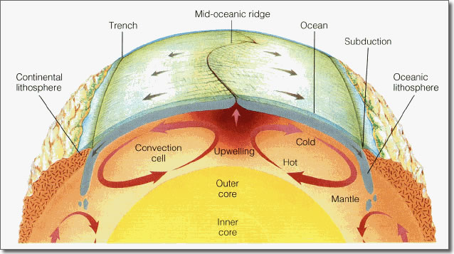
The Earth's crust is not uniform and is broken into many smaller pieces called "Lithospheric Plates".The term 'Lithosphere' includes the earth's crust and the upper mantle. These plates can either be the "Oceanic" plate or the "Continental" plate. These plates float on the inner mantle due to the convection currents occuring inside the mantle. Convection currents describe the rising, spread, and sinking of gas, liquid, or molten material caused by the application of heat.
eg. -> Inside a beaker, hot water rises at the point where heat is applied. The hot water moves to the surface, then spreads out and cools. Cooler water sinks to the bottom.
Similarly, the convection inside the mantle drives plates tectonics through a combination of pushing and spreading apart at mid-ocean ridges and pulling and sinking downward at subduction zones and trenches.
Coming to their types, there are 3 types of plate boundaries :1) Convergent boundaries 2) Divergent boundaries 3) Transform boundaries.
-


Comments
Post a Comment